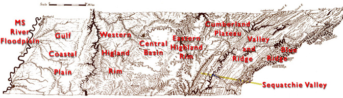
Physical Setting
The MBS is located on the third Chicksaw Bluff, which is Quaternary and Tertiary age blankets of loess rising to ~100 m (350 ft) elevation. The bluffs divide the highly dissected, Tertiary age Gulf Coastal Plain uplands from the Quaternary valley of the Lower Mississippi River. Although the bluffs separate the Mississippi Alluvial Valley from the Gulf Coastal Plain, they are actually considered part of the broad gently sloping landscape of the Gulf Coastal Plain.
Ground elevation within the Gulf Coastal Plain varies from 350' at the edge of the Mississippi River to 600' edge of the Western TN Valley. The gentle rolling topography consists mainly of clays, silts, and sands deposited in shallow seas that would have covered this area in the past. Inland seas would have dominated this area from about 600 mya to ~300 mya. Then a period of uplifting took place mainly in the formation of domes. This region and areas along the Mississippi River would have been around 4000 ft elevation.
However, over time, this area sank ~70 mya and another period dominated by a shallow sea occurred. The trough that formed as the crust sagged formed what is called the Mississippi Embayment. This had also formed periodically in the past. Each shallow sea invasion deposited 100s of meters of sediment, which produced very rich soils in this area. Many of the shallow sea sediments were covered during the Pleistocene (~2 mya – 10,000 BP), large blankets of aeolian derived loess. The loess deposits were thickest along the Mississippi River ~20 m (70 ft) and thin eastward towards the Tennessee River.
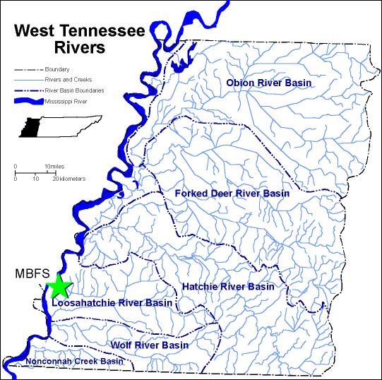
Nearby Flood Plain River Systems
Mississippi River:
The Lower Mississippi River watershed defines the westernmost border of Tennessee. Composed of parts of Dyer, Lake, Lauderdale, Shelby and Tipton Counties, the watershed drains 1549 sq km. Valued for supporting cotton, soybeans and corn farming, the watershed is also prized by duck hunters. The Mississippi River and its watershed provides critical habitat for many different types of wildlife. See our Species page for animals that can be found at the Station.
Mid-sized systems:
The Hatchie River watershed covers 3820 sq km. The watershed includes Benton, Chester, Fayette, Hardeman, Haywood, Lauderdale, Madison, Tippah, and Tipton counties. Although most of the Hatchie River's tributaries have been channelized, the main-stem remains relatively natural.
The Wolf River watershed includes parts of Fayette, Hardeman, and Shelby Counties. It drains 1432 km2 before draining into the Mississippi River. Grain production, logging and industry (in the Memphis area) are major activities in the watershed. Much of the downstream portion of the watershed is heavily urbanized. Sportfishing, boating, duck and goose hunting are all popular.
The Loosahatchie River watershed contains parts of Fayette, Hardeman, Shelby and Tipton Counties and drains 1911 km2 before emptying into the Mississippi River. The watershed supports cotton, soybean and some corn production as well as duck hunting. Fishing is extremely limited.
The Nonconnah Creek watershed contains part of Shelby County and drains 477 km2 before emptying into the Mississippi harbor channel. The watershed is heavily urbanized and supports some commercial nurseries, but very little recreational fishing, hunting or boating.
The Forked Deer River watershed flows through parts of Dyer County and drains 186 km2 before emptying into the Obion River. Farming and hunting are common in this small watershed.
The Obion River watershed contains parts of Dyer, Gibson, Henry, Lake, Obion, and Weakley Counties and drains 3626 km2 before emptying into the Mississippi River. Corn, cotton, and soybeans are valuable commodities grown in the watershed. Sportsmen are attracted to the abundant deer, turkey and gamefish.