Operation and Maintenance of the Arkansas Seismic Network
Arkansas Geological Survey funds nine state-of-the-art permanent broadband seismic stations
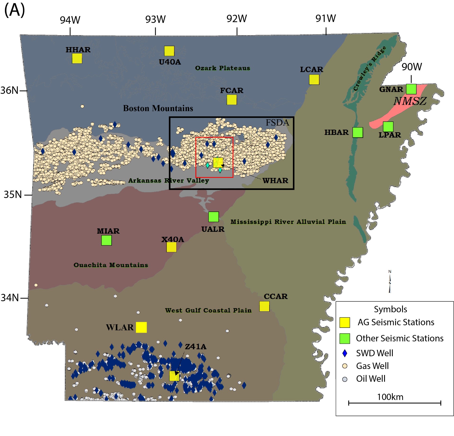
Dr. Stephen Horton, research scientist with the Center for Earthquake Resaerch and Information (CERI), received an award from the Arkansas Geological Survey for his project, "Operation and Maintenance of the Arkansas Seismic Network." This contract supports nine state-of-the-art permanent broadband seismic stations of the Arkansas Seismic Network (AG). The AG Network (Figure 1) was funded through the Arkansas Governor’s General Improvement Fund in response to the Magnet Cove (near Hot Springs), Arkansas earthquake swarm in 2008. The goal of the AG Network is to establish better and more uniform earthquake detection throughout the state outside of the New Madrid seismic zone (NMSZ). The Center for Earthquake Research and Information (CERI) at the University of Memphis has operated and maintained these instruments on behalf of the Arkansas Geological Survey (AGS) from 07/01/2010 to present. This contract of $216,000 ($54,000 per year) covers the period from 11/01/2023 to 10/31/2027.
The AG Network was installed by CERI in the spring of 2010, and it is seamlessly integrates with seismic stations of the Cooperative New Madrid Seismic Network (CNMSN) also located at CERI. The data stream from the AG stations is routinely processed by the CNMSN and made available to the National Earthquake Information Center (NEIC) in Golden, Colorado. Earthquakes exceeding the magnitude detection threshold are automatically located, reviewed by a seismologist, and posted to the Earthquake Notification System (ENS) and the CERI Recent Earthquakes page (http://folkworm.ceri.memphis.edu/REQ3/html/index2.html) seven days a week. Earthquake source parameters are also posted to the CERI and AGS websites. Helicordor images of the data streams from each station are posted to the CERI website in near real-time (http://folkworm.ceri.memphis.edu/heli/heli_bb_ag/). Data is permanently archived and made available through the Incorporated Research Institutions for Seismology (IRIS) Data Management Center (DMC).
This seismic monitoring in Arkansas has led to cooperation between scientific and regulatory agencies to manage seismic hazard from induced earthquakes1. After the first saltwater disposal (SWD) wells associated with the development of the Fayetteville Shale became operational in April 2009, central Arkansas experienced an increase in the rate of earthquakes. This seismic activity in the Fayetteville Shale development area (FSDA) includes both natural and induced earthquakes that often occur in spatial and temporal clusters. CERI and the AGS closely monitor the area using the permanent AG network of seismograph stations, augmented by portable real-time broadband stations, to focus on specific sites of suspected induced seismicity. Any concerns are communicated directly to the Arkansas Oil and Gas Commission (AOGC), the agency charged with regulating SWD wells in the state.
The largest and most significant cluster of induced earthquakes in the FSDA occurred between August 2010 and July 2011, when thousands of earthquakes (M ≤4.7) occurred on the Guy-Greenbrier fault, which had not been mapped prior to the earthquakes2. Since a 13-km-long fault can potentially produce a M 6 earthquake if it slips as a single event, CERI and AGS staff testified at an AOGC hearing in July 2011 that continued fluid injection into SWD wells near the fault could potentially trigger a damaging earthquake. Operators voluntarily shut down and plugged three nearby SWD wells. Another SWD well operator was ordered (by the AOGC) to shut down and plug their well. Earthquake activity dramatically decreased on the Guy-Greenbrier fault and ceased soon after shut-in, thus providing strong supporting evidence that the earthquakes were induced. The AOGC also established a moratorium that prohibited SWD well operations in the area surrounding the fault and rules governing proximity of new SWD wells to mapped faults and proximity of SWD wells to each other. When the price of natural gas rises to make development cost effective, we anticipate the new rules will help to minimize the occurrence of felt and potentially damaging earthquakes.
1Horton, S.P., Ausbrooks, S.M., and Ogwari, P.O., 2023, Managing seismic hazard from induced earthquakes in central Arkansas through cooperation between scientific and regulatory agencies, in Buchanan, R.C., Young, M.H., and Murray, K.E., eds., Recent Seismicity in the Southern Midcontinent, USA: Scientific, Regulatory, and Industry Responses: Geological Society of America Special Paper 559, p. 1–13, https://doi.org/10.1130/2023.2559(01).

Figure 1. (A) Physiographic map of Arkansas. Permanent broadband seismic stations are indicated by yellow squares. Dark blue diamonds are active saltwater disposal (SWD) wells, and cyan diamonds are SWD wells plugged in 2011. Circles are active gas (tan) or oil (gray) production wells. The Fayetteville Shale development area (FSDA) is approximated by the black outline. The Guy-Greenbrier earthquake sequence study area is indicated by the smaller red outline. Locations of gas wells and disposal wells are from the Arkansas Oil and Gas Commission (AOGC). X40A is near Magnet Cove.

