
Freight Transportation Laboratory (FTL)
Co-Directors:
 Dr. Mihalis Gkolias
mgkolias@memphis.edu
901.678.3048
Office: 104B Engineering Science Building
 Dr. Sabya Mishra
smishra3@memphis.edu
901.678.5043
Office: 112B Engineering Science Building
Our Mission
FTL's mission is to develop, implement, and maintaining a comprehensive research program that advances techniques and policies and develops decision support tools that improve performance, reliability, safety, environmental sustainability, and direct capital investment for freight transportation terminals and their networks (physical and information).
Ongoing Projects
Freight data disaggregation
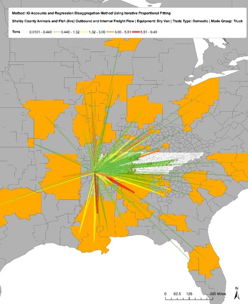 This research project aims to develop models, procedures, and tools to obtain regional,
sub-regional, and jurisdictional level commodity flow data, demonstrate the strength
of models to accurately obtain commodity flow data through case studies, illustrate
the applicability of commodity flow data in travel demand models in TN, and finally
prepare a guidebook that (1) details how commodity flow data should be collected and
disaggregated to be used in local planning models for decision making, and to better
understand freight movement in Tennessee, and (2) identifies and categorizes the current
and rapidly emerging data being collected or processed by the private sector for freight
movements and outline approaches, methods, and analytical techniques that enable local
agencies, MPOs and state DOTs to better carry out their freight planning, programming,
and operations responsibilities.
This research project aims to develop models, procedures, and tools to obtain regional,
sub-regional, and jurisdictional level commodity flow data, demonstrate the strength
of models to accurately obtain commodity flow data through case studies, illustrate
the applicability of commodity flow data in travel demand models in TN, and finally
prepare a guidebook that (1) details how commodity flow data should be collected and
disaggregated to be used in local planning models for decision making, and to better
understand freight movement in Tennessee, and (2) identifies and categorizes the current
and rapidly emerging data being collected or processed by the private sector for freight
movements and outline approaches, methods, and analytical techniques that enable local
agencies, MPOs and state DOTs to better carry out their freight planning, programming,
and operations responsibilities.
Rural Freight
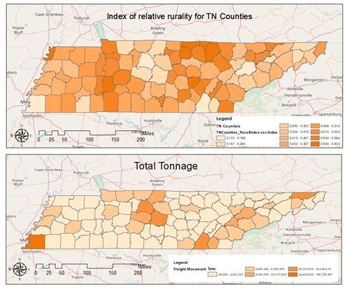 This research utilizes the available freight movement and facility data, the statewide
freight and MPO models, the FAF4 data, to estimate freight impacts at the zip-code
level in the state of TN. The project aims to develop the set of externalities, strategies,
barriers, and critical factors for implementation, the available cost/benefit estimation
methods (both quantitative and qualitative), indicative costs and benefits for each
strategy (whenever possible), and a set of weights that will be used to evaluate and
rank the effectiveness of each strategy for each externality type (i.e., congestion,
noise, emissions, etc.). A weight matrix will be developed based on three data sources:
i) Data from the available literature, ii) Data to be collected from a survey of the
private sector and industry stakeholders, and iii) Data to be collected from the local
communities in TN. This research will also develop an interactive desktop and web-based
GIS data analytics tool that combines all the data collected and streamlines the use
of the data and information developed.
This research utilizes the available freight movement and facility data, the statewide
freight and MPO models, the FAF4 data, to estimate freight impacts at the zip-code
level in the state of TN. The project aims to develop the set of externalities, strategies,
barriers, and critical factors for implementation, the available cost/benefit estimation
methods (both quantitative and qualitative), indicative costs and benefits for each
strategy (whenever possible), and a set of weights that will be used to evaluate and
rank the effectiveness of each strategy for each externality type (i.e., congestion,
noise, emissions, etc.). A weight matrix will be developed based on three data sources:
i) Data from the available literature, ii) Data to be collected from a survey of the
private sector and industry stakeholders, and iii) Data to be collected from the local
communities in TN. This research will also develop an interactive desktop and web-based
GIS data analytics tool that combines all the data collected and streamlines the use
of the data and information developed.
Identifying critical and vulnerable freight routes in roadway networks: A game theory framework and application in the State of Florida.
Golias and Higgs (2016) and Golias et al. (2018) developed a modeling framework and solution algorithms to identify critical and vulnerable paths and links of a transportation network with multiple decision-makers and objectives. In this research, we define a link as critical if a change in its capacity results in a high increase of total travel time for the whole network. On the other hand, a vulnerable link is defined as a link that will experience the highest increase in total travel time (as compared to a base case of normal operating conditions) when a critical link is compromised. This definition does not exclude a link between being both a critical and vulnerable link. In this research, part of the modeling framework by Higgs and Golias (2016) and Golias et al. (2018) will be modified so that it can be applied in a testbed network in the state of Florida with a focus on freight movements. The objective will be to develop a GIS-based application that will help decision-makers identify critical and vulnerable links for freight movements and draw insights (e.g., which parts of the network are extremely vulnerable to loss of capacity in other parts of the network, attack concentration in cases of man-made attacks, cases of total network failure, etc.) as to what optimal investment plans can be.
Optimal Refueling Gas Station Locations in post-evacuation Conditions
Florida State is vulnerable to various forms of natural disasters including hurricanes, tropical storms, tropical depressions, tornadoes, wildfires, and floods. These events regularly affect Florida's residents, visitors, and Florida's economy. Natural disasters are effective and influential vectors for direct and indirect releases of hazardous material (hazmat). Preparedness is the process of turning awareness of the natural hazards and risks faced by a community into actions that improve its capability to respond to and recover from disasters. Recent disasters illustrate the destructive potential of natural hazards and the long-term societal disruption that is felt well beyond the boundaries of the communities that are affected. Directed refueling process of gas stations is one issue that has been the focus for many years because of its importance and its complexity. The main concern for the petroleum supply chain during a natural disaster is its adjustment to the highly increased fuel demand before and after an evacuation. This research focuses on optimizing the process of fuel distribution after a disaster, taking into consideration the changes in the supply chain and roadway network.
Completed Projects
- Truck parking needs.
- Game theory applications for seaport cooperation, competition, and co-opetition.
- Benchmarking freight lanes and identifying dedicated corridor opportunities.
- Improving the resilience of freight networks in West Tennessee.
- Simulating the INDY FedEx Hub: Phase I & II. Federal Express.
- Tennessee SmartPark Pilot.
- Discovering the vulnerable physical routes in a network.
- Evaluating the Hours-of-Service rule via GPS truck trip data.
- GPS/GIS analysis of Tennessee truck trips.
- Simulating the effects of gate strategies in emissions reduction.
- A highway-rail grade crossing prioritization model.